Introduction
The wind energy sector in Victoria has grown rapidly in recent decades. It now supplies more than 12% of the state's energy requirements (DELWP 2020a) and the Victorian government aims to increase this to 50% by 2050 (DELWP 2020b). This will substantially reduce Victoria's current reliance on fossil fuels (DELWP 2020a) but will require constructing many new wind farms. The aim of this report is to identify which sites in Victoria have the best potential to become wind farms.
To site a wind farm requires considering human, environmental and economic factors simultaneously. In Australia, 75% of people support wind farms when surveyed (Lothian 2020) and a significant majority believe that their benefits outweigh their effects on the visual landscape (ibid). Unfortunately, wind farms pose a risk to local bird and bat species who can be injured by the turbine blades (DELWP 2020b). While this risk should of course be avoided, the problem is relatively small compared to other factors such as the risk posed to birds by domestic cats (Woinarski et al., 2017). Finally, for a wind farm site to be sensible it must have sufficient wind velocity as well as be accessible by road and existing electricity infrastructure (Baseer et al. 2017).
Methods
To consider all relevant criteria and to weight their importance appropriately, a GIS based multi-criteria decision analysis (MCDA) was used (Malczewski & Rinner, 2015). The MCDA process began by modelling the preferences of a 'development company' with regards to four objectives (table 1). These preferences corresponded to ratings out of 100 which were then normalised to generate relative weightings. These objectives were reified through the criteria in table 2 and the weighting of each objective was divided equally amongst its criteria.
Table 1: Objectives and Criteria
| Objectives | Criteria | 1 — Very Poor | 2 — Poor | 3 — Moderate | 4 — Good | 5 — Very Good | Rating | Weighting | Weight |
|---|---|---|---|---|---|---|---|---|---|
| Productive Location | Wind speed at 50 m above surface (m/s) | < 5.5 | 5.5–6 | 6–6.5 | 6.5–7 | > 7 | 100 | 100 | 0.308 |
| Accessible | Distance to electricity network (m) | > 5000 | 3000–5000 | 2000–3000 | 1000–2000 | < 1000 | 85 | 28 | 0.087 |
| Distance to roads (m) | > 10,000 | 5,000–10,000 | 2,500–5,000 | 1,000–2,500 | < 1,000 | 28 | 0.087 | ||
| Slope (degrees) | > 10 | 7.5–10 | 5–7.5 | 2.5–5 | < 2.5 | 28 | 0.087 | ||
| Least Human Disturbance | Distance to residential areas (m) | < 1,000 | 1,000–2,500 | 2,500–5,000 | 5,000–10,000 | > 10,000 | 70 | 70 | 0.215 |
| Least Ecological Disturbance | Distance to Protected Areas (m) | < 1,000 | 1,000–2,000 | 2,000–3,500 | 3,500–5,000 | > 5,000 | 70 | 35 | 0.108 |
| Strategic Biodiversity Value | 81–100 | 61–80 | 41–60 | 21–40 | 1–20 | 35 | 0.108 |
A set of value ranges was created for each criterion to judge the suitability of each location in Victoria. The value ranges for wind speed were chosen based on 6 ms⁻¹ at 50 metres being approximately the minimum required for reasonable wind turbine performance (Blakers 2000). Other criteria ranges were modelled on those used in similar studies (Baseer et al. 2017; Saraswat et al. 2021) or to create a linear distribution in the case of the strategic biodiversity value.
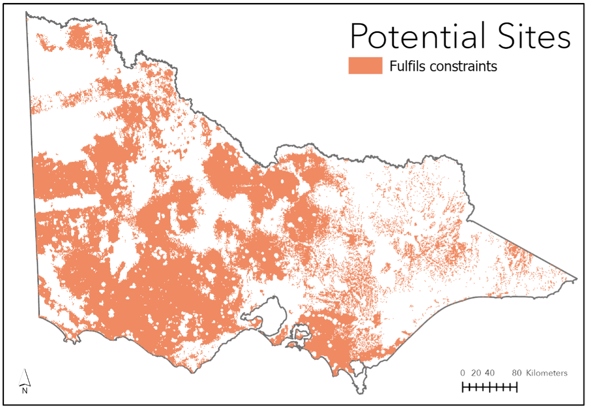
Before the scores could be mapped, an exclusion layer was created (figure 2) which combined exclusion layers for each of the exclusion criteria in table 2.
Table 2: Exclusion Criteria
| Factor | Exclusion Criteria | Source |
|---|---|---|
| Developed area (100 ppl/km²) | Within area | (CIESIN 2018) |
| Distance to airports | Within 3000 m | (DELWP 2021a) |
| Distance to current wind turbines | Within 1000 m | (DELWP 2021c) |
| Distance to residential areas | Within 1000 m | (CIESIN 2018) |
| Protected area | Within area | (DELWP 2021b) |
| Coastal bird habitat | Within habitat area | (Department of Transport 2021) |
| Water body | Within body | (DELWP 2017) |
| Wind speed | Less than 5 ms⁻¹ | (Global Wind Atlas 2021) |
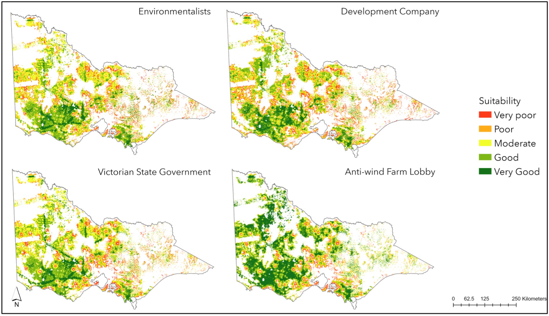
Suitability scores were then mapped by scoring all of Victoria with regards to each criterion. The scores were then combined by taking their weight-adjusted sum. The resulting map was reclassified once more using a natural breaks algorithm. The same process was performed for each of the other stakeholder groups: environmentalists, anti-wind farm lobbyists and the Victorian State Government (see appendix for ratings).
To identify the three most promising potential wind farm sites, another suitability layer was created using ten classes to generate smaller, more discrete regions. The 'regions' tool was then utilised to find the three largest contiguous regions which were in the highest suitability class.
Results
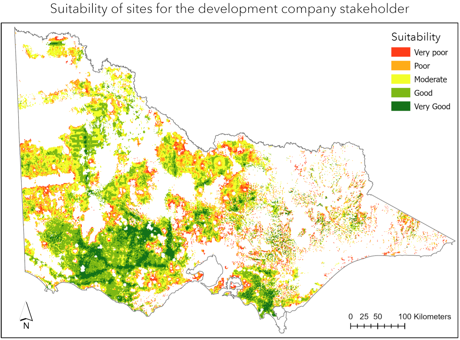
Using the development company stakeholder preferences, the largest areas of Victoria classified as 'Very Good' were in the South-West. This is predominantly due to the high wind speeds in this region compared to the rest of Victoria. Windy coastal and alpine regions were generally not considered due to environmental and access constraints. As can be seen in figure 4, the spatial distribution of suitability between the Environmentalist and Development Company stakeholders was quite similar. In contrast, the Victorian Government and Anti-Wind Farm lobby stakeholder groups had high suitability levels for most locations sufficiently far away from populated areas.
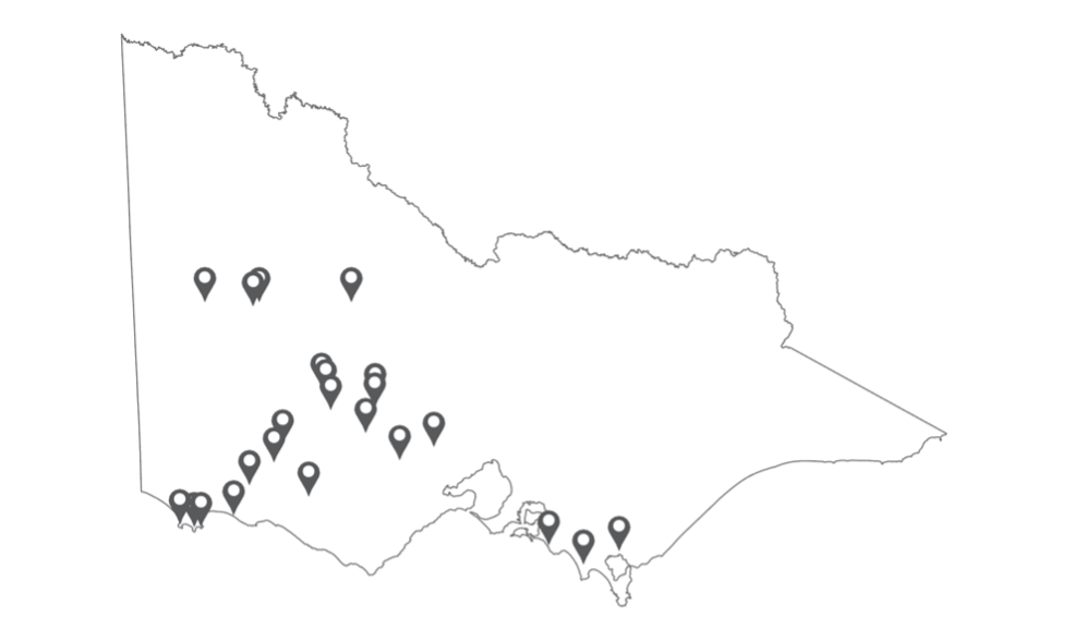
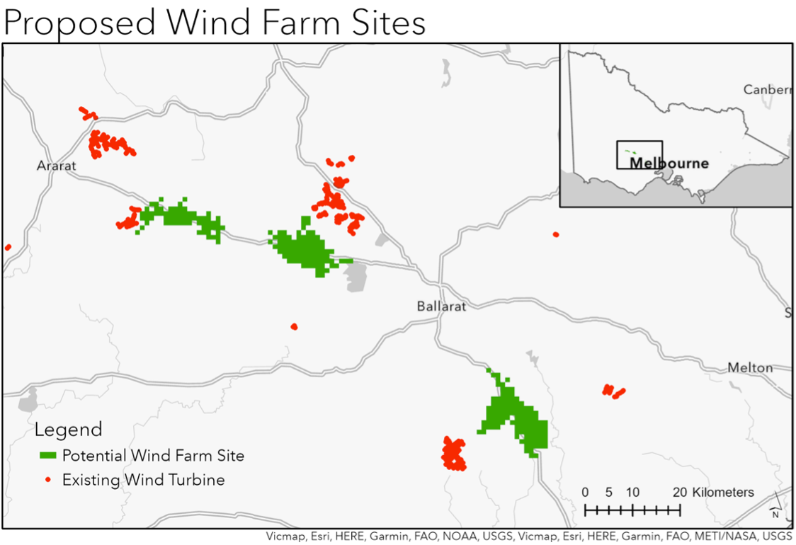
The three potential sites selected can be seen in figure 5, they are located along major roads connected to the City of Ballarat. The selected sites had an average wind speed of 6.33 ms⁻¹ which is greater than the 6.02 ms⁻¹ average of existing wind turbine locations.
Discussion
The three proposed wind farm sites in figure 5 are all located near existing wind turbines. The middle site encompasses an area where a planning permit proposal has already been lodged for a wind farm (DELWP 2021e). This indicates that the study methodology was valid because wind turbines are unlikely to be constructed in these areas if they are truly inappropriate. All three sites appear to be predominantly farmland, hence building wind turbines in these locations would require purchasing or leasing the land from its current owners. Given the high energy productivity potential and accessibility of these sites compared to their low human and environmental impact, they would likely be appropriate additions to the Victorian wind farm system.
The criteria used to score each objective seems to have been appropriate. The areas with the highest suitability scores are far away from cities and wildlife areas. The addition of the strategic biodiversity values meant that important areas for Victorian ecosystems which are not formally protected were still considered in the analysis. However, the accessibility criteria may require internal reweighting as the slope of the terrain is arguably less important than proximity to power lines and roads.
The limitations of the study are most evident in the small number of datasets used and their limited resolution. For example, the use of only mean wind speed may hide considerable variability in wind speeds throughout the year. While seabird habitat data was used to exclude some coastal areas from the analysis, information about inland bird distribution and migratory paths should also have been included (Taoufik and Fekri, 2021). The use of a km² cell size meant that potentially suitable shorelines were poorly resolved and that small distance restrictions were at times not accurately represented.
Another issue in this analysis was the subjective nature of the criteria score intervals and the interpretation of suitability scores. Most similar studies used a more objective 'fuzzy set' approach to define their criteria scores (Aydin et al., 2010; Sánchez-Lozano et al., 2016). Another analysis approach such as cost-revenue optimisation (Van Haaren & Fthenakis, 2011) may have provided a more objective threshold for when a site is considered viable.
The practical outcome of this study is to drastically reduce the search area for any party wishing to construct a new wind farm. It demonstrates that there is an abundance of suitable area for wind farms to be constructed in Victoria to expand its wind power capacity.
References
Aydin, N.Y., Kentel, E., Duzgun, S., 2010. GIS-based environmental assessment of wind energy systems for spatial planning: A case study from Western Turkey. Renewable and Sustainable Energy Reviews 14, 364–373.
Baseer, M.A., Rehman, S., Meyer, J.P., Alam, Md.M., 2017. GIS-based site suitability analysis for wind farm development in Saudi Arabia. Energy 141, 1166–1176.
Blakers, A., 2000. Solar and wind electricity in Australia. Australian Journal of Environmental Management 7, 223–236.
Department of Environment, Land, Water & Planning (DELWP), 2020a. Victorian Renewable Energy Target 2019-20 Progress Report.
Department of Environment, Land, Water & Planning (DELWP), 2020b. Wind Farms Fact Sheet – Large scale wind energy generation in Victoria.
Department of Environment, Land, Water & Planning (DELWP), 2021e. Wind energy projects. planning.vic.gov.au.
Lothian, A., 2020. A survey of the visual impact and community acceptance of wind farms in Australia. Landscape and Urban Planning 56, 217–227.
Malczewski, J., Rinner, C., 2015. Introduction to GIS-MCDA, in: Multicriteria Decision Analysis in Geographic Information Science. Springer, Berlin, pp. 23–54.
Sánchez-Lozano, J.M., García-Cascales, M.S., Lamata, M.T., 2016. GIS-based onshore wind farm site selection using Fuzzy Multi-Criteria Decision Making methods. Applied Energy 171, 86–102.
Saraswat, S.K., Digalwar, A.K., Yadav, S.S., Kumar, G., 2021. MCDM and GIS based modelling technique for assessment of solar and wind farm locations in India. Renewable Energy 169, 865–884.
Taoufik, M., Fekri, A., 2021. GIS-based multi-criteria analysis of offshore wind farm development in Morocco. Energy Conversion and Management: X 11, 100103.
Van Haaren, R., Fthenakis, V., 2011. GIS-based wind farm site selection using spatial multi-criteria analysis (SMCA): Evaluating the case for New York State. Renewable and Sustainable Energy Reviews 15, 3332–3340.
Woinarski, J.C.Z., et al., 2017. Compilation and traits of Australian bird species killed by cats. Biological Conservation 216, 1–9.
Data Sources
Airport Layer
DELWP, 2021a. Airport Area - Vicmap Transport. discover.data.vic.gov.au
Coastal Bird Habitats Layer
Department of Transport, 2021. Coastal bird habitats on the Victorian coast. discover.data.vic.gov.au
Conservation Areas Layer
DELWP, 2021b. Parks and Conservation Reserves (PARKRES). services.land.vic.gov.au
Current Wind Turbine Layer
DELWP, 2021c. FOI - Point - Vicmap Features of Interest. discover.data.vic.gov.au
DEM Layer
Geoscience Australia, 2010. 3 second SRTM Digital Elevation Model (DEM) v01. data.gov.au
Land Cover Layer
DELWP, 2017. Victorian Land Cover Mapping 2016. discover.data.vic.gov.au
Population Density Layer
CIESIN - Columbia University, 2018. Gridded Population of the World, Version 4 (GPWv4): Population Density, Revision 11. sedac.ciesin.columbia.edu
Sealed Road Layer
DELWP, 2021d. Road Network - Vicmap Transport. discover.data.vic.gov.au
Transmission Line Layer
Orr, K., Allan, B., 2015. Electricity Transmission Lines. Geoscience Australia. doi:10.4225/25/553DC89AD105C
Strategic Biodiversity Values Layer
DELWP, 2019. NaturePrint v4.0 Strategic Biodiversity Values. discover.data.vic.gov.au
Vic LGA Layer
Department of Industry, Science, Energy and Resources, 2014. VIC Local Government Areas. data.gov.au
Wind Speed Layer
Global Wind Atlas, 2021. globalwindatlas.info
Appendix
Appendix Table 1: Criteria Details
| Criteria | Description | Source |
|---|---|---|
| Wind speed at 50 m above surface | The wind speed at approximately the height at which turbines are expected to be positioned (ms⁻¹) | (Global Wind Atlas 2021) |
| Distance to electricity network | The distance to the nearest high voltage electricity transmission line (m) | (Orr & Allan 2015) |
| Distance to roads | The distance to the nearest sealed road (m) | (DELWP 2021d) |
| Slope | The angle of slope at a given position (°) | (Geoscience Australia 2010) |
| Distance to residential areas | The distance to the nearest area with a population density of greater than 100 people per km² | (CIESIN 2018) |
| Distance to Protected Areas | The distance to the nearest conservation area as designated by the Victorian Government | (DELWP 2021b) |
| Strategic Biodiversity Value | The relative importance of an area to the conservation of biodiversity in Victoria (1–100); lower values indicate areas where major developments should be placed to minimise impact | (DELWP 2019) |
Appendix Table 2: Stakeholder Ratings
| Objective | Development Company | State Government | Anti-Wind Farm Lobby | Environmentalists |
|---|---|---|---|---|
| Productive Location | 100 | 50 | 30 | 75 |
| Accessible | 85 | 80 | 30 | 50 |
| Least human disturbance | 70 | 90 | 85 | 40 |
| Least ecological disturbance | 70 | 30 | 50 | 100 |